Tables for calibrating altimeters and computing altitudes based on the standard atmosphere
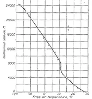
A 1927 technical report of tables for calibrating aircraft altimeters and computing altitudes from the standard atmosphere, issued by a government aeronautics research body for pilots and instrument engineers. The single picture is a plain line graph of isothermal altitude in feet against free air temperature in degrees Celsius, with plotted data points joined by a curve and a sharp kink near 8,000 feet, offering a designer a clean scientific chart with a grid and axis labels.