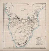
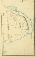
Inner Africa laid open, in an attempt to trace the chief lines of communication across that continent south of the equator; with the routes to the Muropue and the Cazembe, Moenemoezi and Lake Nyassa; the journeys of the Rev. Dr. Krapf and the Rev. J. Rebmann on the eastern coast; and the discoveries of Messrs. Oswell and Livingstone in the heart of the continent
Inner Africa Laid Open is an 1852 London work by geographer William Desborough Cooley, published by Longman, Brown, Green, and Longmans, tracing trade and exploration routes across southern Africa for a geographical readership. Its two plates are hand-coloured-style copper-engraved maps: one rotated sideways showing rivers, mountain shading and a coastline, and one upright full map of southern Africa with graticule lines, place names in small italic type, and a decorative cartouche and scale bar a designer could borrow for antique cartographic framing.