Statistical atlas of the United States
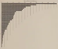
Statistical atlas of the United States, published in Washington in 1903 by the United States Census Office after the 12th census of 1900, a government reference work of population and vital statistics for the nation. The picture is a horizontal bar chart with bars descending from a long top bar of about 60 million bushels, measured on a scale from 0 to 90 millions of bushels, with thin guide lines dropping from each bar to the axis. A designer could borrow its dense ranked-bar structure, thin gridlines and tapering rhythm for data graphics and infographic layouts.