Topographia Alsatiæ, &c. : das ist, Beschreibung vnnd eygentliche Abbildung der vornehmbsten Stätt vnd Oerther, in Obern vnd Untern Elsass, auch den benachbarten Gundgöw, Graffschafft Mümpelgart, vnnd andern Gegenden
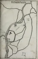
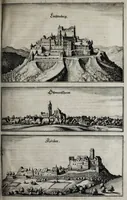
Topographia Alsatiæ is a 1644 German topographical survey of towns and places in Alsace and neighbouring regions, written by Martin Zeiller and published in Frankfurt by Matthäus Merian for readers interested in regional description and travel. The pictures are black-and-white copperplate views: a siege-style plan of a fortified town with roads and a compass rose, and three elevation views of hilltop castles and walled towns, useful to a designer for crisp historical cartography and early-modern architectural profiles.